
World
Tropical Depression Verbena Approaches Cuyo Islands, Forecasted to Impact Northern Palawan Tonight
Juancho Mabini
24 Jan, 2026
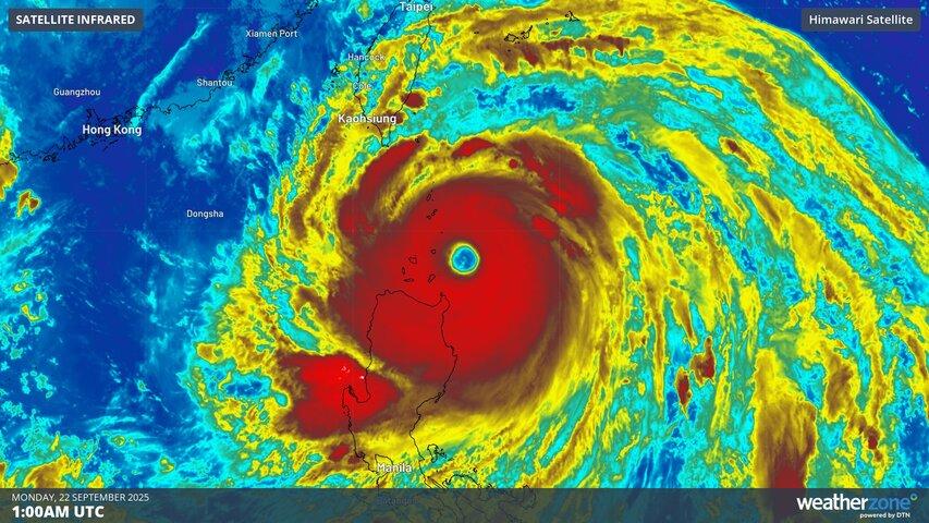
Tropical Depression Verbena is moving toward the Cuyo Islands as of Tuesday afternoon, with meteorologists predicting its arrival over northern Palawan by tonight. The cyclone was last pinpointed near the coastal waters of Magsaysay, Palawan, sustaining maximum winds of 55 kilometers per hour and gusts up to 70 kph.
The Philippine Atmospheric, Geophysical and Astronomical Services Administration (PAGASA) has maintained Tropical Cyclone Wind Signal No. 1 over multiple areas in Luzon and Visayas. This signal warns of wind speeds reaching up to 61 kph in the following regions:
-
Luzon: Occidental Mindoro, Oriental Mindoro, Romblon, northern and central Palawan municipalities including Araceli, Taytay, El Nido, Dumaran, Roxas, San Vicente, Puerto Princesa City, as well as Calamian, Cuyo, and Cagayancillo Islands; mainland Masbate municipalities including Balud, Mandaon, Milagros, Cawayan, Placer, Pio V. Corpuz, Esperanza, Uson, Dimasalang, City of Masbate, Mobo, Palanas, Aroroy, Cataingan, and Baleno.
-
Visayas: Antique, Aklan, Capiz, Iloilo, Guimaras, and the western part of Negros Occidental—encompassing cities and towns such as Himamaylan, Binalbagan, Isabela, Hinigaran, Pontevedra, La Carlota City, Moises Padilla, La Castellana, Valladolid, San Enrique, Bago City, Pulupandan, Bacolod City, Talisay City, Silay City, Enrique B. Magalona, Victorias City, Manapla, Murcia, Ilog, Kabankalan City, Cauayan, Sipalay City, Candoni, and Hinoba-An.
After making landfall in Palawan, Verbena is expected to continue westward into the West Philippine Sea and leave the Philippine Area of Responsibility by Thursday.
PAGASA has also issued a gale warning over several regions due to anticipated rough to very rough seas. Sea travelers and coastal communities are advised to exercise caution during this period. The highest expected wave heights are:
- Up to 6 meters: Seaboards of Batanes, Babuyan Islands, Ilocos Norte, and Ilocos Sur.
- Up to 5 meters: Seaboards of Kalayaan Islands and northern mainland Cagayan.
- Up to 4.5 meters: Remaining seaboards of the Ilocos Region and mainland Cagayan.
- Up to 4 meters: Western seaboards of northern mainland Palawan and Calamian Islands.
- Up to 3.5 meters: Seaboards of Isabela, Aurora, northern mainland Quezon, Camarines Norte, Antique, Cuyo Islands, western Occidental Mindoro including Lubang Islands, eastern Albay and Sorsogon, southern Occidental Mindoro and Oriental Mindoro, northern and eastern Polillo Islands, Catanduanes, and Northern Samar.
- Up to 3 meters: Western seaboard of Bataan, eastern seaboards of Eastern Samar and Dinagat Islands, northern and eastern seaboards of Siargao-Bucas Grande Islands.
- Up to 2.5 meters: Seaboards of Marinduque, Romblon, Aklan, Surigao del Sur, Davao Occidental; eastern Oriental Mindoro, Camarines Sur, Davao Oriental; western Negros Occidental and other parts of Palawan; remaining seaboards of Quezon and Catanduanes.
- Up to 2 meters: Seaboard of Batangas and Bantayan Islands; northern Negros Occidental; remaining Occidental Mindoro, Oriental Mindoro, Bicol Region, and Northern Samar.
Authorities continue to monitor Tropical Depression Verbena and urge the public to stay updated on weather advisories as the situation develops.
Recommended For You

Oriental Mindoro Governor Commends Teams for Successful 75th Founding Anniversary Celebration
Jan 24, 2026
Ligaya Almeda

Leptospirosis Cases Surge in Cebu Amid Post-Flood Health Concerns
Jan 24, 2026
Isagani Llorente

Mandaue City Councilor Urges Strict Enforcement of Storm Ordinance to Promote Rainwater Harvesting
Jan 24, 2026
Amado Panganiban
DEPDev to Develop River Basin Master Plan by Next Year to Enhance Flood Control
Jan 24, 2026
Ligaya Almeda