
World
Tropical Disturbance Enters Philippine Area, Forecast to Develop into Tropical Depression Wilma
Ligaya Almeda
24 Jan, 2026
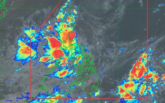
The Philippine Atmospheric, Geophysical, and Astronomical Services Administration (PAGASA) reported that a low pressure area (LPA) entered the Philippine Area of Responsibility (PAR) at 2 p.m. on Wednesday, December 3. Positioned approximately 1,095 kilometers east of southeastern Luzon by 3 p.m., the system remains distant and poses no immediate threat to the country.
However, PAGASA has indicated a high probability that the LPA will intensify into a tropical depression within the next 24 hours. Upon development, it will be designated as "Wilma," the 23rd tropical cyclone of 2025 and the first to form in December.
The weather bureau anticipates one or two tropical cyclones will enter or form within PAR this month. In preparation, PAGASA issued an initial rainfall advisory at 5 p.m. on Wednesday, highlighting significant rainfalls expected towards the end of the week, particularly in Eastern Visayas and the Bicol region.
Rainfall Forecast:
-
Thursday afternoon (Dec. 4) to Friday afternoon (Dec. 5): Moderate to heavy rains (50–100 mm) are forecasted in Northern Samar and Eastern Samar.
-
Friday afternoon (Dec. 5) to Saturday afternoon (Dec. 6): Moderate to heavy rainfall (50–100 mm) is expected over Catanduanes, Camarines Sur, Albay, Sorsogon, Northern Samar, Eastern Samar, Samar, and Biliran.
Residents in these areas are advised to prepare for potential flooding and landslides.
In addition, the northeast monsoon (locally known as "amihan") is bringing moderate to occasionally heavy rains to Cagayan Valley and the Cordillera Administrative Region, with isolated light showers in parts of the Ilocos Region and Central Luzon.
Furthermore, the presence of a shear line—where cold air from the northeast monsoon meets warm easterly winds from the Pacific Ocean—could cause scattered rain and isolated thunderstorms in Aurora, Quezon, and Camarines Norte.
PAGASA also noted that the intertropical convergence zone may trigger scattered rain and thunderstorms in Basilan, Sulu, and Tawi-Tawi, raising concerns about possible flash floods and landslides.
Officials continue to monitor the situation closely and urge the public to stay alert for updates as the weather conditions evolve.
Recommended For You

Leptospirosis Cases Surge in Cebu Amid Post-Flood Health Concerns
Jan 24, 2026
Isagani Llorente

Philippines Upholds Two-State Solution and Solidarity with Palestine Amid Ongoing Middle East Conflict
Jan 24, 2026
Isagani Llorente

Former DPWH Official Becomes State Witness in Flood Control Project Probe
Jan 24, 2026
Juancho Mabini
DigiPlus Interactive Plans Localized Livestream Bingo for Brazil Market
Jan 24, 2026
Dorotea Balagtas